Today's navigation technologies are powerful tools that are used in many areas of life and support economic and social growth. The capabilities of satellite systems directly affect the efficiency of business expansion and help to conquer new heights. Application of current satellite navigation technologies and mobile communications allows you to track in real time the exact location of objects and personnel, shows routes of movement and correct following the route, determines movement data (mileage, speed), in addition, notes fuel consumption and analyzes the performance of units and components. Navigation systems are increasingly appearing in our everyday life, becoming no longer an elite item, available not only to citizens, but also not to all enterprises, but a common means of daily monitoring of personnel and vehicles. Despite the obvious problems of operating systems of this kind, their use is becoming commonplace in an increasing number of enterprises. Since 2010, I have been professionally involved in the subject of satellite monitoring of transport and would like to consider the problem - how to deceive the GPS/GLONASS transport control system? This topic is topical for all drivers. I will try to answer the question objectively, from the perspective of an independent expert.
In the review, I collected and analyzed situations from both my personal experience, as well as suggestions on forums on the topic of “neutralizing GPS”.
Everyone knows that the monitoring system includes two components - a terminal (controller unit, recorder, car tracker, etc.) and a fuel level sensor, FLS. Let us consider in detail whether it is realistic to interfere with the processes of these two components together or separately.
Ways to influence the operation of the Glonass terminal
Method of influencing the operation of the terminal. The box with the electronic components inside is the external unit. Some models have a built-in backup battery, while others do not, but all models provide for an external connection to the vehicle’s on-board power supply. For the most part, for industrially produced monitoring systems, external GPS (GLONASS) and GSM antennas are used. Usually, the terminal block is sealed, and advice that you need to remove the SIM card for the required time and then return it to its place does not justify itself. Since the SIM is located just inside the block body. Some reckless drivers, having lost their composure, use a risky method - they pour water or other liquid onto the device. However, in practice it turned out that after a visit by representatives of the installer company in order to consider the reasons for the breakdown of the internal elements of the unit, the operating company had to part with the negligent driver, and the employee, in turn, begged not to fine him for the damage caused. I think it became clear to everyone that it is impossible to influence the terminal block unless you simply break it. There are also external antennas and connection lines to the vehicle’s on-board wiring. How can you really influence them?
1. Turn off the power. Many are confident that when the device is disconnected from the power supply, the driver will be able to move around in his own interests, and when returning to his place, turn on the power again, as if nothing had happened. Too primitive a technique. “Getting excited” in front of your superiors is like twice two. Firstly, the built-in battery is located in most units; it keeps the system in operation for up to several tens of hours. And, in turn, the dispatcher will receive a signal to turn off the external power. And also, if there is no battery, the dispatch center will still receive such a signal indicating the time to turn it off and on. Let us mention separately that all the wires of the terminal are connected to the board through knife terminal blocks, which are sealed, so it is simply impossible to disconnect the wire without damaging the seal. It became obvious that this method was not viable either. Let's think further.
2. Interference with the antenna. The option of disconnecting the antenna will not work, because these units have seals by default. The method of shielding the GPS antenna is of interest; it needs to be covered with a metal cup, foil or magnet. The signal from the satellites should, in theory, disappear. It seems we have found a solution! But again, not everything is so easy. I’ll explain it clearly - you can cover it with a saucepan, firewood, or a bulletproof vest - the result will be the same. Working with modern highly sensitive GPS receivers, the best that can be achieved with this method is to reduce the number of satellites visible to the terminal. For example, instead of twelve to thirteen GPS satellites, which are visible when the antenna is open, there will be five or six if you cover it with a 20 mm thick sheet of metal. But you need to understand that to obtain accurate coordinates, the device only needs to use signals from only three satellites. Thus, this method is also not applicable in real life. There is no point in shielding the GSM antenna, because this is equivalent to moving the car outside the GSM network coverage area. The device accumulates data in memory for several months, but after the network appears, every single byte of information will be transferred to the dispatcher on the server. If we try to disable the antenna, we will face the following problems: The GPS antenna is sealed and without damaging the housing it is not possible to influence the internal elements in any way. GSM does not have any “brains” inside at all, representing strip conductor tracks in a plastic case - piercing them with a needle is pointless; there will be no harm. The most vulnerable place here is the cable - from the terminal to the antenna. You can pierce it with something sharp and, if you're lucky, it will stop working for a while. But you should be aware that this method is a contemporary of Ivan the Terrible, and the first GPS specialist who will restore its functionality will easily determine the cause and, having found the puncture site, will report it to your superiors. In the same way, facts of mechanical interference in the operation of antennas will be determined with 100% certainty. high voltage. Method for “two” on a five-point scale.
3. Special equipment. Perhaps the only fail-safe method of bypassing GPS monitoring systems is to use electronic devices to suppress GPS or GSM radio signals. The advantages of the method are that the effect occurs remotely, without direct penetrating contact in the device's wiring circuit or circuitry. What happens in the tracking system when we activate a GPS or GSM signal suppression unit nearby (for example, in the vehicle cabin)? We have already discussed that blocking the signal does not threaten anything serious, since you cancel the transfer of data to the dispatch server and are out of communication during this period. But at the moment the “jammer” is turned off, the data for the entire trip (during this period they were stored in the device’s memory) will be immediately received by the dispatcher. Accordingly, unauthorized driver routes will be displayed on the computer screen.
If the GPS signal is suppressed, things will look different. In this case, the location of the vehicle simply disappears from the monitor screen, while the coordinate data will not be stored in memory, since satellite signals there is no way to create them. Everything would be great, but the method will only work with the simplest devices, called GPS trackers, they cannot additionally connect to vehicle signals, with the exception of power connections. GPS service specialists, without exposing you on the spot, will not be able to explain to the customer the riddle in which, upon leaving the garage, the car miraculously disappears from the monitor screen, and by the same miracle appears upon return. The GPS installer's representative can see through the driver's trick by driving with him during business hours. When a system that is slightly more complex than the simplest tracker is installed in a vehicle, there is no point in using a GPS jammer, since data from the signal wires - fuel system data, ignition, engine speed (tachometer) - will be transmitted and displayed on the computer screen, which will confirm the functionality of the system, thereby compromising the driver's actions. Certain systems, for example, Glonass GPS, can also be connected to the speedometer. And if the GPS system loses the signal, the dispatcher will see the real mileage on the screen! The method is not bad, but it is intended only for young, inexperienced systems installers. Seasoned representatives will see through the driver in an instant. The method earned a “C” on our scale.
There are probably no more ways to interfere with the terminal mechanisms at an amateurish level. Let us examine in detail the following component of the GPS control system:
Methods of intervention in the FLS - Fuel Level Sensor.
Theoretical information. The Fuel Level Sensor (FLS) is a structure consisting of: a measuring part - 2 tubes of different diameters (one is located inside the other) and a computing part (at the top there is a housing that carries the controller board, as a rule, it is filled with a gasoline-resistant compound that prevents the influence of an aggressive environment on radioelements (oil, gasoline, diesel fuel, etc.). All sensors have the same operating principle for measuring liquid levels - a change in the electrical capacitance in the “capacitor plates” by the sensor tubes, depending on the medium being measured. And the output signal itself may vary. There are modifications with an analog signal at the output (0-5 V or 0-10 V), frequency (changing the frequency of the output signal from the sensor), and digital - RS-232. It is most protected from possible interference when transmitting data to the terminal. The computing part of the FLS is made either in a non-separable form, sealed (FLS Strela, FLS Control, etc.), or in disassembled form, and it is possible to seal the sensor cover (DUT-E from Technoton). It should be remembered that there is no “handle” in nature for adjusting the FLS readings. And there are the following “combinations”:
1. Short circuit of wires, which go from the FLS to the body of the vehicle - minus or to the plus of the vehicle. The system will be temporarily inoperable, but nothing major will happen. When the wires are put back, the sensor will become operational again thanks to the built-in protection against voltage changes in the on-board network and changes in power poles. To summarize, I will say: the method is ineffective or completely ineffective. All connection points are sealed by the installers, and it will not be possible to do without breaking the seals. The bosses will see through you instantly, the method gets the minimum score - “one”!
2. Watering with boiling water. Some believe that in winter you can take advantage of the temperature difference and thus upset the calculation unit by heating it with hot water and pouring it onto a cold sensor. One driver confessed to me in this unseemly matter. He had no doubt about the success of the technique, and organized a “bath” every day for six months, but he never saw the fruits of the experiment. Strela heroically withstood this torment. For the future, I want to explain to experimenters why the method is useless. The FLS body is made of metal and therefore quickly transfers the resulting heat to the fuel tank. There is also a plastic case, which makes it difficult for the sensor to heat up at all, because plastic is a poor heat conductor. Considering all that has been said, and remembering the gel-like compound that reliably fixes the board and protects it from contact with the sensor body, we can say for sure that such schemes will not work. It’s true that there’s not much chance of getting caught by management – we give the method a solid “B”.
3 . Another rather bold idea - physically break the sensor, which is mounted on a full-height tank, and desperate young people are trying to make it happen. We climb onto the tank (it’s not bad to have significant weight), and jump up, pushing through the lid of the tank with our weight. In this way we try to break the measuring tube on the sensor. Everything seems simple, but again it’s not so. The technology for installing a FLS in a tank always calculates a gap of one and a half to three cm between the bottom of the tube on the sensor and the bottom of the tank. And you need to make a lot of effort to dent the tank so deeply. In addition, individual sensors are equipped with a spring; it is installed at the end of the DUT tube and will resist the attempts of a jumping craftsman (such sensors are produced by Technoton). And, of course, it will not be possible to deceive the installer that “it broke on its own,” and the driver of the vehicle is innocent. You will have to pay - the guarantee does not apply here. Who will pay for the repairs depends on the decision of the vehicle owner.
I also include trivial cases when sensor tubes are bent by fittings when the fuel tank is not closed. The method is rated low for easy detection and a high penalty for broken equipment.
4.
Against the background of the simplest schemes to deceive the system, this method looks somewhat fresh: seal the holes at the air drainage, which is located at the top of the FLS, under the “intelligence” cover. One or more holes are used so that the liquid reading on the sensor can change along with the overall level in the tank. If we seal it, we get no changes in the amount of fuel over time. That is, the dispatcher will see a straight line on the fuel graph. The main inconvenience of this method is that you can only reach the holes if you disconnect the sensor mount on the tank. The Technoton company seals its FLS mount; this is provided for by its design and configuration. Other manufacturers such as Strela, Control, etc. They don’t put seals on their fastenings.
5.
A memorable incident from personal experience. The driver admitted that he found the following advice online and tried it in practice. In accordance with the found “guidance”, you should fill on moving equipment, and after a while drain about 20 liters of fuel from the tank. According to the author from the Internet, this trick is 100% correct: the device instantly goes crazy and then should freeze for good. But I will say with all responsibility, this is nonsense! Drivers, don’t create a circus by playing with fuel and lubricants on the go - this way you can “kill” the car without achieving any results. There is a much more “intelligent” option, discussed below...
6. Draining fuel from the return line. In fact, perhaps a unique way to “competently” bypass almost any control system that uses a fuel level sensor (FLS). The idea of the method is that with a small amount of fuel taken, it will not be possible to automatically distinguish between drainage and increased consumption of fuel and lubricants. The usual version is to insert a tee with a tap, through which fuel flows in a thin stream into the canister. During a shift, a lot can be filled, but the system will not catch the drain. The same action occurs when fuel is taken from a “stove” that uses diesel fuel as fuel. This method is correct only under 2 conditions: an illiterate dispatcher who is too lazy to understand situations in detail and a careless mechanic (garage manager) who turns a blind eye to what is happening and fully understands where and which driver placed the tee. If luck favors you, and the mentioned persons do not come to an agreement with the drivers, then draining from the return line is unlikely. The dispatcher will quickly note the increased consumption of the vehicle, and the mechanic will, without wasting time, catch the driver red-handed on the road. If unsuccessful, it will not be easy for the driver to explain the reason for the “intrusion” into the vehicle’s fuel line. The “five” method on our scale.
7.
We should also remember the riskiest way to deceive GPS/GLONASS monitoring systems. I call it “Riding in Russian”. The essence of the idea is that while the vehicle is moving, disconnect the ground, the diesel engine will continue to function and the car will be completely de-energized, as well as the navigation unit. If the system has an internal battery, the device will detect the coordinates of movement along the route, but when there is no battery, the system will display a “jump” from one point to another. This method requires a highly qualified driver, since only an experienced, and in some way crazy, driver can afford to drive a completely de-energized car, with electrical appliances turned off.
To summarize the review on this issue, I would like to note the following: any of the listed options for deceiving the navigation system and satellite control will be successful only when the driver control department works carelessly. We have a fairly wide range of client companies that are negligent in operating their equipment, and this is wasted money. However, there are also enterprises that monitor the operation of the system in an exemplary manner; their money spent paid off in 1-2 months, and the rest of the time the money will be saved. Time, as we know, is money, and a lot of it.
Geolocation is the process of finding the iPhone's location. Unfortunately, the importance of geolocation is usually underestimated, despite the fact that without it it will not be possible to use a navigator, attach geotags to a photo, or find using the function of the same name. Users are more familiar with the negative characteristic of geolocation – “gluttony”: by disabling the function, you can significantly increase the duration battery life gadget.
Fortunately, the procedure for activating/deactivating geolocation is quite simple - you can turn it on while using the navigator, and keep it off the rest of the time.
The user encounters a request to activate geolocation during the initial setup of the iPhone and, as a rule, unknowingly confirms it. Therefore, the issue of disabling geolocation is more pressing than turning it on. You need to deactivate the function like this:
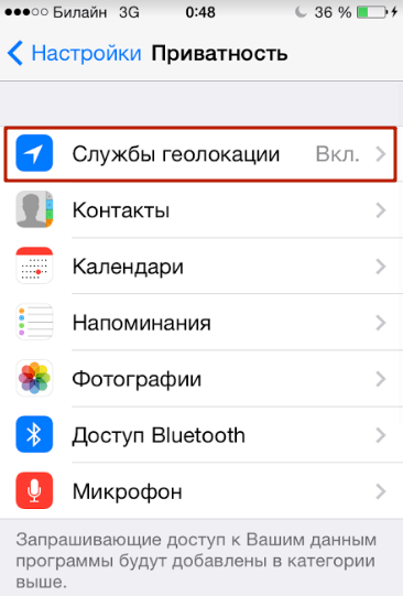
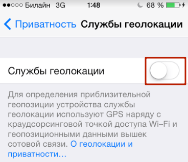
Step 1. IN " Settings"find the section " Privacy" (on some versions of iOS - " Confidentiality") and go into it.
Step 2. Proceed to the subsection " Location services" - he comes first on the list.
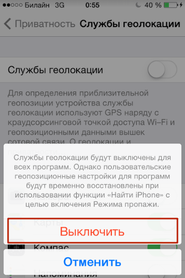
Step 3. Switch the toggle switch " Location services» to the inactive position.
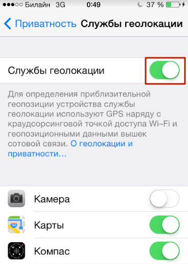
Step 4. Confirm your intention to deactivate geolocation - click " Switch off».
Please note that the iPhone has flexible settings: you can allow some applications to use geolocation, and prohibit others. To do this, you need to adjust the sliders located in the block below.
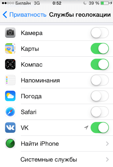
For example, with the configuration as in the figure, you will be able to use navigation, but geotags will not be attached to your photos.
With flexible settings, the main toggle switch " Location services" must be enabled.
Do I need to disable geolocation of system services?
Subsection " System Services" is located at the very bottom of the block with a list of applications that require geolocation.

A user who visits this subsection will see the following:

Before deciding whether you need to disable geolocation for system services, you should understand what functions at least some of them are designed to perform.
The system services listed are common to most iOS versions. There is no need to describe all services - and it is clear that their main goal is to collect confidential data on consumer preferences and sending information to Apple. People who claim that Americans are spying on Russians through smartphones are not too far from the truth.
If you do not want Apple to replenish its statistical databases by tracking your movements and purchases, switch the toggle switches in the “ System Services» to the inactive position. It is recommended that all Yabloko members do this: There is no benefit to the iPhone owner from the services, but the charge is consumed faster because of them.
How to enable geolocation on iPhone?
The algorithm for how to enable geolocation on an iPhone differs only slightly from the disabling method described above only slightly. The user also needs to follow the path " Settings» — « Privacy» — « Services geolocation" In the last section, he will see that there is only one slider (the main one), and there is no list of applications that use geolocation.
You need to activate the toggle switch, then disable geolocation from those applications that do not really need this function.
Are geolocation and GPS the same thing?
Users who believe that geolocation and GPS are synonymous are mistaken. Geolocation– this is a general concept associated with determining the location of a device; GPS is a trademark of the American satellite system navigation. Most often, geolocation uses GPS technology – hence the misconception about the equivalence of concepts.
However, in order for geolocation to be available, it is not at all necessary to turn on GPS - other ways to calculate positional data are possible:
- Via Bluetooth. The location of the object is determined using special beacons Beacon, which are located in public buildings - airports, hypermarkets. In terms of accuracy, this technology is inferior to GPS, because it provides reliable results only if the object is stationary.
- Based on mobile communication stations. The smartphone knows from which station the GSM signal is sent to it and where this station is located. Therefore, using a special application containing a database of stations, you can use geolocation without GPS. Reliable results using this method can be achieved in megacities where the network coverage density is high, but in small cities determining geolocation through stations is problematic.
- Based on the Earth's geomagnetic field. Navigation based on the planet’s geomagnetic field is the idea of Saratov scientists. Each point on Earth has a unique set of characteristics, which can be used to determine the location of an object (including an iPhone). The technology is only being tested, but large advances are already being given to it.
Although geolocation and GPS are different concepts, and there are several ways to calculate positional data, this moment quite accurate The location of an object can only be determined via GPS.
What to do if geolocation doesn't work?
If geolocation does not work, it is unlikely that there is a mechanical failure of any part of the iPhone (for example, the GPS module). Most likely, the problem lies at the software level. What to do if the function refuses to function?
Step 1. Proceed to the section " Location services» and make sure that geolocation is activated for a specific application.
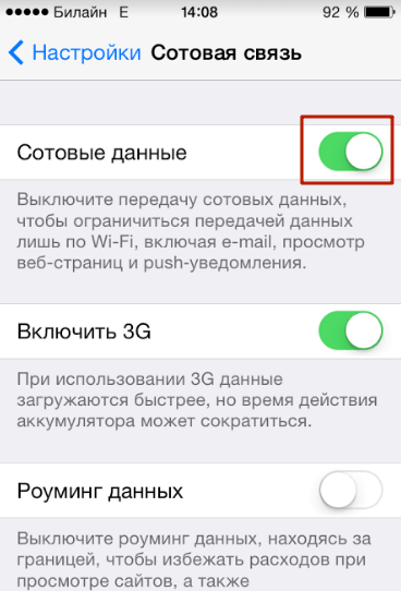
Step 2. Check if the Internet is turned on on your iPhone. The network makes it possible to more accurately position the device. Go to the section " cellular» Settings and make sure the Cellular Data slider is in the active position.
Step 3. If the above steps do not produce results, reset the settings after creating a backup copy (instructions for creating copies can be found). Follow the path " Settings» — « Basic» — « Reset" and select " Erase content and settings».

This reset will erase all data from your iPhone.
You need to check whether geolocation works on a “clean” smartphone, that is, before restoring from backup copy. If the function still does not work, you should contact the service.
More often than others, owners of a jailbroken iPhone encounter problems with geolocation. Such users are recommended to install from the store Cydia tweak called libLocation: It is completely free and helps in better positioning of the jailbroken gadget.
Conclusion
If you don't know what it is geotags for photos, and consider navigation on an iPhone unnecessary, most likely you don’t need the geolocation function at all. It is recommended to turn it off - thanks to this measure, you can ensure that your gadget “lives” offline longer. Don't forget about deactivation system services, which do not bring any benefit to the owner of the gadget, but drain the battery faster.
Almost everything mobile devices, working under the control operating system Android, be it smartphones or tablets, are equipped with a GPS module. The geopositioning system allows you to determine the location of the device and its owner with an accuracy of several meters. This, of course, is good, especially when it comes to navigation or accurate search results, but it results in increased battery consumption and a couple of other problems.This is why it is very important to properly configure GPS on Android to get the most out of this component.
Why do you need GPS in a smartphone and how is it used?
The location system is used in Android not only for navigation, but also in a number of other cases.
For example, many Google applications actively and constantly determine the location of the smartphone and its user. The obtained data is used for a variety of purposes.
Thus, Google Search helps you find nearby cafes, restaurants and other establishments. Just type into the search bar “Where you can eat”, like smart system will display a list of nearby catering outlets. Shops, train stations, hospitals, public institutions and other organizations - nothing can hide from the omnipresent “eye” of Google, and the search giant will help you find those that are closest to the searcher.
GPS is also used to create reminders linked to geographic coordinates. This functionality is implemented in Google Keep. There you can make a list of products and set a reminder so that the application displays a corresponding notification as soon as the smartphone - and its owner - is in the store.
Of course, in this case, GPS is a tool, and it is up to the user how it will be used.
GPS is also used in the camera - coordinates are “attached” to the photographs taken. This is excellent proof that the photograph taken from the top of Elbrus is not the result of photoshopping, and it was taken exactly there, on this mountain.
Anti-theft devices also operate based on GPS positioning. All programs that allow you to find a lost Android device require the smartphone location module to be enabled. And yes, it works!
And finally, GPS is also used in navigation, be it working with cartographic systems ( Google Maps, Yandex Maps) or directly determining and plotting a route (Navitel, 2GIS).
In general, the GPS module is a useful thing. Well, except for a few “buts”.
Why you should turn off GPS in Android
However, GPS is not a panacea at all, but rather a double-edged sword. The geolocation system can cause some trouble.
The first problem is, of course, the increasing battery consumption. GPS is a fairly resource-intensive technology that eats up the battery with great appetite. Even top-end smartphones cannot work for more than 4-5 hours with the positioning module turned on and active, let alone less “advanced” devices.

The second problem is that too many applications want to know the user's location. And if you want to trust the same Foursquare with information about where you are, then some kind of alarm clock that accesses GPS causes at least bewilderment.
In addition, Google collects and stores information about all the user’s “travels,” about his locations at various dates and times, and this is somehow strange and causes mild attacks of paranoia even in those who are not particularly suspicious.
Leaving GPS on or turning it off forever is a personal decision for each user. But it's still worth setting up this service.
Setting up GPS in Android
First of all, go to the “Settings” application of the Android operating system. This is where the bulk of the manipulations will take place. The item we need is called “Location”.

What can you do with GPS at this point? Actually, it can be turned on or off - to do this, just move the corresponding slider. When it is turned ON, GPS and coordinates can be accessed by any application that is given the appropriate permission.

The Recent Geo Queries list shows all the apps that have attempted to locate the user in the last few hours. Thanks to this, you can “catch malware” - a program that collects data about the user and does not use it for the benefit of that user (as Google does).
But the most main point location settings - this is Operation Mode. Modern smartphones are equipped not only with a GPS module, but also with A-GPS technology. It allows you to determine your location with more or less high accuracy, even if the device cannot communicate with positioning satellites.

A-GPS uses various data to operate - information from towers cellular communications(in this case, the triangulation technique is used) and information from available points Wi-Fi access, even if the device is not connected to them.
So, modern smartphones have 3 modes of operation of the GPS module: by all sources, by network coordinates and by GPS satellites.
The first mode is precisely the implementation of A-GPS technology. The smartphone uses all available sources to determine its location. This could be positioning satellites, cell tower coordinates, data from Wi-Fi access points, or all three. Working in this mode allows for the highest accuracy in location determination, regardless of whether the device is located outdoors or indoors, but leads to increased battery consumption.
The second mode turns off the GPS module - and then data from towers and access points is used to determine coordinates. This allows you to save a lot of battery power, especially if Wi-Fi is also turned off, but it degrades the positioning accuracy – up to a range of several blocks.
You can further reduce battery consumption by turning off Wi-Fi in A-GPS. The instructions are described in the article "".
Of course, to position using network coordinates, it is not necessary for the device to be in the field of view of the satellites. Therefore, if you use this mode, the location will be determined equally poorly regardless of where the Android device is located: indoors or outdoors.
The third mode disables A-GPS technology, and the device begins to try to determine its coordinates solely by geopositioning satellites. Battery consumption in this case is also quite high, but lower than in the A-GPS + “pure” GPS combination, accuracy is within a few meters. The only “but” is that if you move the smartphone indoors (or into a tunnel, for example, in general, you deprive it of the ability to “see the sky”), and it loses contact with satellites and, along with it, orientation in space.
In this way, you can set the optimal GPS operating mode.
You can then enable or disable geodata transfer. The switch is located in Settings, in the “curtain” or on the corresponding widget.

Optimal GPS settings on Android
If you need to provide maximum time battery life, it is better to set the GPS operating mode to “Only by GPS satellites” and completely disable it from Settings, “curtain” or widget. Thanks to this, battery power will not be consumed trying to determine the location of the device.
Then, when GPS is still needed, for example, if you need to plot a route from point A to point B, you can turn it on - from the settings, “curtain” or widget.
If you want to take advantage of all the benefits of always-on positioning (for example, personalized search results in Google app), but you don’t want to run with your smartphone to the outlet every three hours, then you can turn on the “Only by network coordinates” mode. Unfortunately, it is not suitable for navigation. The geolocation service itself should be left enabled.
And finally, if the battery charge is not too important - you still have to “run to the outlet” two or three times a day, then you should turn on the “By all sources” mode and leave the service turned on. This ensures maximum positioning accuracy both indoors and outdoors.
When it comes to modern technologies There can often be a trade-off between privacy and convenience. The same location feature that can recommend a good coffee shop near you or show your boarding pass at the airport can also cause trouble. But we will tell you how to turn off location tracking in Android OS if you no longer want the device to know where you are.
What locations does Android track?
The very first time you start your Android device, you will be asked if you want to share your location with others. If you select Yes, Google will automatically add your movements to your location history, which you can view in your Google Account.
According to the company Google history locations "helps you get useful information, such as automatic suggestions for your daily commute or improved search results. To do this, a personal map is created with the places you visit.

But if the card has limited access, what's the problem?
We didn't say there was any problem! But not everyone feels comfortable knowing that their every move is being monitored. If you lose your device, the information could be obtained by people with criminal intentions. If you were a burglar, we think you would be interested in knowing where a person lives, when he leaves and when he returns from work.
In addition, it is likely that information about your movements could sooner or later be used against you in court, especially if it indicates that you were somewhere you should not have been. And of course, some people are simply uncomfortable knowing that some private companies are aware of their every move.
What could be the disadvantages of disabling location tracking?
You'll lose some of the functionality that makes Android so convenient. A Google Now that doesn't know your favorite places won't be as useful as apps that rely on location services. On the other hand, by turning off GPS, you save your battery power.
How to disable location tracking in Android OS

There are 2 ways to stop tracking your movements. On your computer, follow the link https://www.google.com/settings/accounthistory> Places you've visited > Manage history, then click on “Disable history”; A pop-up window will display information about which services will be affected by disabling history, and will show a link where you can delete your entire travel history at once.
It's even easier on an Android device.
- Open the Settings menu
- Scroll down to Location
- In the top right corner, you will see an On/Off switch. Using this, you can turn the location service on or off.
- Tap on Location > Location History
- In the same upper right corner you will find a switch with which you can turn off the history of your movements
If you want to delete an already saved history, you can do the following: while in the “Location History” section, click on the “Delete Location History” button located at the bottom of the screen. Once deleted, this information cannot be restored.

How to turn off location tracking on iPad and iPhone
If you have an Android phone and an iOS tablet, or vice versa, then you will also need to check the location settings of the second device. Apple devices can also store your location and share it with apps. To turn off location tracking, go to Settings > Privacy > Location Services. If location services is enabled, you will see a list of applications with the following information: first, you will see whether location services is enabled for the individual application, and second, whether it has been used in Lately information about your location.
There is also another section here - System Services - which allows you to disable the use of location information at the system level, i.e. for functions such as geolocation advertising, browser search suggestions, setting time zones, etc. Just disable any services you don't need.
How to re-enable location tracking on Android
If you suddenly find yourself missing Google Now, or realize that your movements aren't interesting enough for strangers, you can easily turn location tracking back on. This time you will need:
- Open the Settings menu
- Scroll down the screen to “Location”
- Tap on Location > Google Location Settings
- In the upper right corner, drag the slider to the “On” position.
- Click on “Location History” and also drag the slider in the upper right to the “On” position.
You will have to do similar actions with Apple devices: Go to Settings > Privacy > Location Services and use the buttons to turn location tracking back on.
What do you think? Do the benefits of location services outweigh the potential hassles that may arise from using them? Share your opinion in the comments!
Almost all modern smartphones are equipped with a GPS chip. The navigation module is present in most tablet computers operating under the Android operating system. However, not all users know that the chip is often disabled by default. As a result, such people are surprised that there are no geotags in the photographs, and Google service Now does not show the route to your home. Fortunately, you can enable GPS on your tablet and smartphone without any effort.
Why do you need GPS?
Decades ago, GPS satellites were only available to the military. But the Americans quickly realized that big money could be made from navigation chips, applications and maps. As a result, ordinary people gained access to the technology - they just needed to acquire the appropriate device. Initially, these were specialized GPS navigators. And now the navigation module has seriously decreased in size, and therefore it can be built even into an ordinary smartphone.
A GPS signal helps you understand where in the world you are now. This is useful for several reasons:
- The navigation app will help you not get lost in the forest;
- With navigation you can navigate even in an unfamiliar city;
- You can easily find the address you need;
- You escape from traffic jams - the “Traffic” service helps you avoid them;
- Various apps show you nearby eateries and shopping centers;
- GPS helps determine your speed.
In short, a navigation chip can be very useful. But you will have to pay for using it. If you decide to turn on GPS on Android, then get ready for higher power consumption. This is most noticeable on older devices that do not support A-GPS technology. Also, inexpensive ones have a problem with GPS signal reception. Ours will help you get closer to solving it.
GPS activation
But enough of the lyrics... Let's find out how to turn on GPS on your phone under Android control. This is done very simply:
Step 1. Go to the device menu and tap on the “ Settings».
Step 2. Here select " Location».

Step 3. Click on the item " Mode».

Step 4. Select location mode " According to all sources" or " By GPS satellites».

On smartphones running more than current versions Android GPS can be enabled via the notification panel. To do this, just activate the button "GPS"(depending on the manufacturer, it may have a different name). By long pressing on this item you can go to the location settings and change other parameters. For example, enable energy saving mode or high accuracy.

Note: On smartphones and some other devices, the item names may differ. For example, the section " Location" may have the name " Geodata».